Whose footprint is it?
Sri Pada is 2,243 m (7,360 ft) and is the only mountain in the world claimed as a sacred footprint by four religions at once. The formation near the summit is about 1.8 m long — one account gives it precisely as five feet three and three-quarter inches long and between two feet five and two feet seven wide. Buddhists hold it the footprint of the Buddha, left on his third visit to the island at the invitation of the deity Saman, following the Mahavamsa. Hindus read it as Shiva’s — the Tamil name Civan-oli-pata means the mountain path of Shiva’s light — or as Hanuman’s. Muslims hold it Adam’s, which is where the English name comes from. Christians attribute it to St Thomas the Apostle. These are four traditions, not four findings, and the honest way to present them is as claims with dates attached.
The documentary trail is long and checkable. The Chinese monk Fa Hien, in Sri Lanka in 411–412 CE, mentions Sri Pada. The first historical Sri Lankan mention comes with King Vijayabahu I (1055/58–1110/14), who ascended, worshipped the footprint and dedicated the village of Gilimale to supporting pilgrims; his stone inscriptions survive at Gilimale and Ambagamuwa. King Nissanka Malla (1187–1196), ruling from Polonnaruwa, climbed with his fourfold army and did much to establish the organised pilgrimage. Marco Polo noted it as a major pilgrimage site in 1298. Ibn Battuta climbed it in 1344 and described a stairway with iron stanchions and chains. The first recorded English ascent was by Lieutenant William Malcolm on 26 April 1815, and John Davy described the footprint in 1817.
The mountain sits inside the Peak Wilderness Sanctuary, declared on 25 October 1940: 224 km², the third largest of Sri Lanka’s fifty sanctuaries, spanning 300 to 2,240 m, and the source of the Kelani, Kalu and Walawe rivers plus tributaries of the Mahaweli. A Peace Pagoda was built midway up the Nallathanniya side by the Japanese Nipponzan Myohoji order in 1978.
 Sri Pada 07Photo: Bernard Gagnon (CC BY-SA 3.0)
Which way up, and what is on each route?
- Nallathanniya (Dalhousie) trailThe main and shortest route, Raja Mawatha: about 5–7 km with roughly 5,500 steps, four hours up and two and a half down. In season it is illuminated all night and lined with tea stalls. Almost every visitor uses this one.
- The summit plateau and the footprintA small plateau about 74 ft by 24 ft — roughly 1,776 square feet in all — with the enshrined footprint at its centre. It is not a large space, which is why crowding in season is a real problem rather than an inconvenience.
- The summit bellsTwo bells at the top. The tradition is that a pilgrim rings once for each successful ascent they have made, so the count tells you how many times the person at the rope has been up. Ask them; they will tell you.
- The Peace PagodaBuilt in 1978 by the Nipponzan Myohoji order, midway up the Nallathanniya side, and the obvious marker of how far you have come.
- Ratnapura–Palabaddala trailThe oldest and hardest route, and the classic pilgrim’s way, via the Gilimale and Carney estates. Length is published as 8.5 km by one source and 15 km by another; either way it is 8–12 hours, with better facilities and far more of them.
- Seetha GangulaThe icy river crossing on the Ratnapura route — “the icy water river”, and the parent stream of the Kalu Ganga. Pilgrims traditionally bathe here before the final ascent.
- Indikatupana and HeramitipanaNamed stations on the Ratnapura ascent, each with its own tradition; Heramitipana is the high, exposed rest area and the last major stop before the final climb. Lihini Hela and Ehela Kanuwa are further landmarks on the same route.
- Kuruwita–Erathna trailTwelve kilometres and 8–12 hours, the third of the historic routes, running through the Peak Wilderness. Current condition and safety are not something we can confirm.
- Rajmale–Murraywatta trailFive kilometres and 3–5 hours — the least-known short option. At the other extreme, Dehenakanda–Mukkuwaththa is 15 km and 12–15 hours, and was opened in 1933.
What most visitors walk straight past
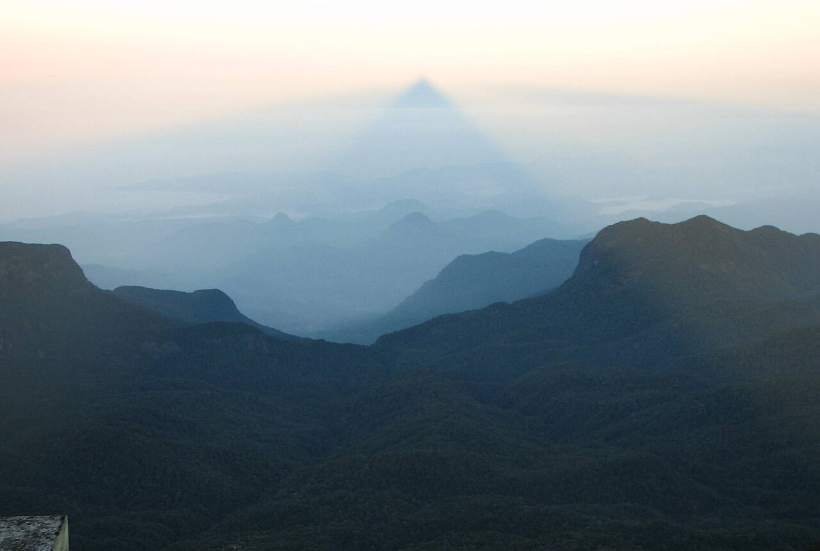
The shadow, not the footprint, is the reason to be up there at dawn. The mountain throws a perfect triangular shadow that appears to hang suspended in the air in front of the peak for around twenty minutes. The odds are roughly 80% during the pilgrimage season and drop to about 40% or lower outside it.
Ibn Battuta’s chains, 1344. The chains and iron stanchions he described are the direct ancestors of the handrails pilgrims still grip on the steepest section. Very few handholds anywhere have a 680-year written pedigree.
Ring the bell as many times as you have climbed. A quiet, precise custom, and the easiest conversation to start on the summit: the number of rings is the number of ascents.
Four claims, each with a date. Fa Hien in 411–412 CE; Vijayabahu I’s inscriptions at Gilimale and Ambagamuwa in the eleventh century; Marco Polo in 1298; Ibn Battuta in 1344; the first English ascent on 26 April 1815; Davy’s description in 1817. Being able to date the claims is what turns a vague line about four religions into something worth hearing — and it keeps them as traditions rather than dressing them up as findings.
It was navigation infrastructure before it was a shrine. The conical silhouette was used as a seamark by the Arab traders who called the island Serendib.
In season you climb in a river of light; out of season you climb a dark mountain. During the pilgrimage months the whole staircase is illuminated and small stalls and tea shops open through the night. Outside them there is no lighting, nothing open, no food or water on the route, and the summit temple activity ceases. They are two completely different climbs.
Three rivers from one massif. The Peak Wilderness is the source of the Kelani, the Kalu and the Walawe, plus Mahaweli tributaries. You are standing on the island’s principal watershed.
The Ghost Herd. A herd of roughly 20–50 elephants lives in the Peak Wilderness — the only remaining wet-zone and montane elephant population in Sri Lanka. You will not see them from the steps, but it is what the forest below you contains.
A toad back from the dead. Adenomus kandianus, once ranked the world’s rarest toad, was rediscovered in the Peak Wilderness in October 2009 after 133 years unrecorded.
Where to stay in Adam’s Peak
We earn a small commission if you book through these links, at no extra cost to you. It costs you nothing and it does not change what we recommend — the notes above are what travellers actually report, not what pays best.
What do travellers actually say about Adam’s Peak?
n = 30 traveller reports · public traveller forums · gathered August 2026
Thirty reports name it, and most of that count is actually Little Adam’s Peak in Ella — a forty-minute walk and an entirely different hill. The genuine Sri Pada material is a handful of passages, and it is consistent.
- The real Adam’s Peak is climbed overnight to reach the summit for sunrise. Heat is not the problem here; the summit is cold, and you stand still in it waiting for the light.
- Season matters more than fitness. In the pilgrimage season, roughly December to May, the path is lit and staffed. Outside it the questions people ask turn on landslides and flooding rather than on difficulty, and a rain shell, headtorch and boots are treated as the minimum.
- Access is from Nallathanniya (Dalhousie), and the sequence planned around it is Kandy, then Nallathanniya, then Nuwara Eliya, then Ella. It is a genuinely awkward leg on public transport.
- This is what Sri Lankan beginners climb first. It is the entry point to local hiking culture rather than an expert objective, which is worth saying to a guest who has been told it is an expedition.
- Do not confuse the twoLittle Adam’s Peak in Ella is a short sunrise walk that appears in almost every itinerary — and it also appears on the list of places where people have had photograph-related accidents.
- Worth doing before you commitTravellers check a public road-status site to see whether the Kandy–Nallathanniya–Nuwara Eliya roads are open before booking the leg. In the wet months that check is the difference between a climb and a very long drive.
Where travellers disagree. How long the climb actually is. The step count is given as “around 5,500” with no primary source behind it, and the Ratnapura-side route is published as both 8.5 km and 15 km. On the ground the real argument is about season rather than distance: in season the staircase can become a standing queue on poya days and April weekends, turning a four-hour climb into something much longer in the cold, while out of season it is an unlit night walk on wet granite with nobody else on the mountain and no help available.
Questions people ask about Adam’s Peak
When can you climb Adam’s Peak?
The pilgrimage season runs from the Duruthu poya in December, occasionally January, to the Vesak poya in May, and one account frames it as December full moon to April full moon. Those dates move every year, so check them annually. April is the peak of the season. Outside it the route is unlit, nothing is open and there is no food or water on the way up.
How hard is it?
The Nallathanniya route is about 7 km with roughly 5,500 steps, four hours up and two and a half down, and it is what Sri Lankan beginners climb first. It is stairs rather than mountaineering. The difficulty is the hour, the cold at 2,243 m and the fact that you stand still at the top waiting for sunrise.
Will you see the shadow?
Probably, if you go in season — the triangular shadow appears to hang in the air in front of the peak for around twenty minutes after dawn, and the odds are roughly 80% during the pilgrimage season. Outside it they fall to about 40% or lower. That shadow, not the footprint, is what people remember.
Which route should you take?
Nallathanniya unless you have a reason not to: it is the shortest, it is lit and stalled in season, and it is four hours up. The Ratnapura–Palabaddala route via Gilimale and the Carney estate is the historic pilgrim’s way and takes 8–12 hours — a serious undertaking, and the one to choose only if the pilgrimage itself is the point.
What should you carry?
More warm clothing than feels sensible at the base, because you climb from warm air to 2,243 m and then stop moving. Out of season add a torch with spare batteries and take a companion. Guides run about LKR 1,500–2,000 and are worth it for solo women and for any out-of-season night climb; we could not verify any entrance fee for the pilgrimage itself.